


Airborne Noctilucent Cloud Tomography

Fundamentally, high-resolution time-lapse imagery may be used to test theories of noctilucent cloud formation, sublimation, advection and gravity wave perturbations. Together with the Royal Canadian Air Force (RCAF), Columbia University and the University of Alberta, PoSSUM graduates observe and analyze the time evolution of the noctilucent cloud field over many hours from high-resolution cameras designed for high-altitude balloon flight that will be coordinated with ground and satellite observations. PoSSUM has worked with the RCAF to make these measurements from a CT-155 ‘Hawk’ high performace aircraft and also led citizen science research campaigns from High Level, Alberta as part of AER 103, where airborne observations using a Turbo Mooney aircraft are coupled with two ground stations, one near High Level, AB. and the other near Garden Creek, AB. The research aircraft will fly a carefully-crafted flight plan at altitudes of up to 21,000’ employing scientific camera systems qualified for high-altitude balloon and suborbital noctilucent cloud imagery.
Science Objectives
PoSSUM airborne noctilucent cloud campaigns have several objectives: 1) validate camera systems on noctilucent clouds structures, 2) characterize jitter and focal capability in varying flight environments, 3) obtain imagery data to assist preliminary design of image algorithms, 4) perform tomographic imagery synchronous with ground station(s), and 5) facilitate EPO efforts.
–
Following the flight campaign, an analysis will be performed to: 1) compile the images, 2) compare the viewing angles, geometries, local time, scattering angles, and the positions of the aircraft and the clouds being imaged, and 3) analyze the micro-features of the PMCs in images taken simultaneously with ground observations and the AIM satellite.
PoSSUM – Royal Canadian Air Force Noctilucent Cloud Research


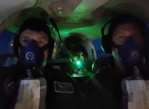
From 29 June to 1 July, 2018, PoSSUM Scientist-Astronaut Candidate Capt. Theon Te Koeti, Executive Director Dr. Jason Reimuller, and PoSSUM Education and Public Outreach Director Adrien Mauduit conducted high-altitude research using a CT-155 ‘Hawk’, training aircraft, thanks to CAE, located at the Royal Canadian Air Force’s 15 Wing at Moose Jaw, Saskatchewan. Operating from the Edmonton International Airport, a series of night flights were conducted along the 56th parallel at altitudes of up to 45,000 ft. From these altitudes, the team was able to image fine structures of noctilucent clouds that the team hopes will reveal more about the highly complex patterns of turbulence and instability in our upper atmosphere. The research was coordinated with NASA’s Science Mission Directorate’s PMC Turbo balloon, led by PoSSUM Chief Scientist Dr. Dave Fritts, which was the first dedicated mission to explore the small-scale dynamics of our mesosphere. It is also the first balloon mission to employ a balloon-borne lidar system. PoSSUM next will attempt to validate the imagery taken by aircraft with that of the PMC-Turbo balloon to determine if small-scale turbulence could be discernable from aircraft.
PoSSUM Citizen-Science Noctilucent Cloud Research
AER 103: Citizen-Science Airborne Tomography from High Level, AB
AER 103 is an OPERATIONAL FIELD CAMPAIGN based in High Level, Alberta. All students will learn to operate at high-altitudes (up to 21K’) in unpressurized aircraft while performing one of two in-flight roles: flight navigator or mission specialist. Students will also participate in coordinated ground observation campaigns to facilitate tomographic reconstruction of airborne images.
–
Teaching Objectives: 1) Provide a foundation in operational flight research. 2) Learn how to integrate and test imagery systems to aircraft, 3) Learn how to organize operational field campaigns and sorties using PoSSUM research aircraft to study noctilucent clouds, 4) Learn effective Crew Resource Management techniques in operational aircraft campaigns, 5) Learn about high-altitude physiology and the effective use of supplemental oxygen, 6) Learn to calculate waypoints for each sortie type. Webinars will be provided and class projects will be assigned.
–
PoSSUM Student Roles and Responsibilities:
Flight Navigator: Calculate all waypoints, calculate intercept times (using winds aloft) at each waypoint, engine settings to intercept waypoint on time given winds aloft data. Program waypoints in GPS system on aircraft prior to flight and aviation digital map.
Flight Mission Specialist: Operate instrument in-flight. Set camera settings using GUI interface for camera system, position camera azimuth at each waypoint, monitor total oxygen level for crew. Download and backup all camera data after flight.
Ground Support 1 and 2: Set up and operate ground camera for tomography imagery.
